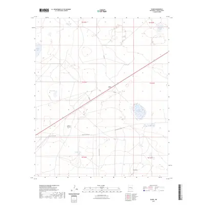
2023 Map of Elkins
USGS Topo · Published 2023About this map
The settlement of Elkins serves as a central point in this high plains landscape of Chaves County, situated where U.S. Route 70 intersects with local routes like Llaves Rd and Organ Rd. This arid environment is defined by a sparse but vital network of water catchment systems, including several small lakes and named tanks such as Seesaw Tank, Barringer Tank, and Cocklebur Tank. The presence of these water features alongside ranch roads like White Lake Ranch Rd suggests a landscape historically oriented toward livestock and high-desert transit.
Find a feature on this map
25 named features on this map. Tap any name to fly to it.
Don’t see what you’re looking for? This feature index may not catch every label — zoom into the map to look around manually.
Map Details
Editions of this 2023 Elkins Map
This is the sole edition of this map. No revisions or reprints were ever made.
Other maps of this area

1954 · Brownfield
USGS Topo · 1:250,000

1955 · Roswell
USGS Topo · 1:250,000

1958 · Brownfield
USGS Topo · 1:250,000

1958 · Roswell
USGS Topo · 1:250,000

1962 · Roswell
USGS Topo · 1:250,000

1962 · Brownfield
USGS Topo · 1:250,000
1967 · Campbell
USGS Topo · 1:24,000

1967 · Haystack Mountain
USGS Topo · 1:24,000
1967 · Haystack Butte
USGS Topo · 1:24,000

1967 · Elkins
USGS Topo · 1:24,000