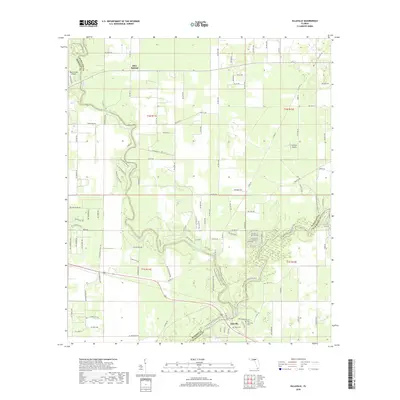
2018 Map of Ellaville
USGS Topo · Published 2018About this map
The Suwannee River and Withlacoochee River converge in the southern reaches of this landscape, marking the intersection of Madison, Hamilton, and Suwannee counties. The settlement of Ellaville sits at this significant river junction, once a site of major timber production. The map illustrates a region defined by its hydrogeology, featuring numerous groundwater discharge points such as Withlacoochee Spring, Morgans Spring, and the prominent Blue Springs. These natural features, along with the intermittent Dry Run, shaped the historical settlement patterns and transport routes of the area. Local history is preserved at the Old Columbus Cem and Dean Cem, which offer physical links to the early residents of this river-centered community. Small local airstrips, including Blue Springs Airport and DJ Farm Airport, indicate the modern character of the rural landscape alongside traditional agricultural and woodland areas.
Find a feature on this map
123 named features on this map. Tap any name to fly to it.
Don’t see what you’re looking for? This feature index may not catch every label — zoom into the map to look around manually.
Map Details
Editions of this 2018 Ellaville Map
This is the sole edition of this map. No revisions or reprints were ever made.
Other maps of this area

1954 · Valdosta
USGS Topo · 1:250,000

1956 · Jennings
USGS Topo · 1:24,000

1956 · Octahatchee
USGS Topo · 1:24,000

1958 · Valdosta
USGS Topo · 1:250,000

1958 · Fort Union
USGS Topo · 1:24,000

1958 · Madison SE
USGS Topo · 1:24,000

1958 · Lee
USGS Topo · 1:24,000

1959 · Valdosta
USGS Topo · 1:250,000

1959 · Ellaville
USGS Topo · 1:24,000

1959 · Live Oak West
USGS Topo · 1:24,000