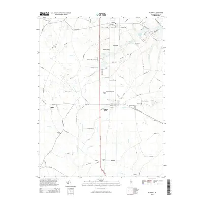
2014 Map of Ellendale
USGS Topo · Published 2014About this map
Ellendale and Lincoln anchor this 2014 survey of central Delaware, where the landscape is defined by a dense network of small residential enclaves and quiet water bodies. The geography is characterized by clusters such as Lincoln Village, Hilltop Acres, and Walkers Acres that sit between the many small streams and ponds that drain the region. Of particular interest to genealogists are the scattered burial sites, including Ellendale Cem, New Market Cem, and Banning Cem, which mark the presence of established communities like New Market and Oakley. The map reflects a modern rural-suburban hybrid, where traditional named settlements persist alongside newer developments like Sussex Woods and Hudson Pond Acres. Water features like Clendaniel Pond, Cabbage Pond, and Swiggetts Pond are central to the terrain, feeding into winding branches like Sowbridge Br and Gravelly Br.
Find a feature on this map
113 named features on this map. Tap any name to fly to it.
Don’t see what you’re looking for? This feature index may not catch every label — zoom into the map to look around manually.
Map Details
Editions of this 2014 Ellendale Map
This is the sole edition of this map. No revisions or reprints were ever made.
Other maps of this area

1915 · Seaford
USGS Topo · 1:62,500

1917 · Millsboro
USGS Topo · 1:62,500

1918 · Cedar Creek
USGS Topo · 1:62,500

1918 · Harrington
USGS Topo · 1:62,500

1919 · Cedar Creek
USGS Topo · 1:62,500

1938 · Cedar Creek
USGS Topo · 1:62,500

1938 · Millsboro
USGS Topo · 1:62,500
1944 · Milton
USGS Topo · 1:24,000

1944 · Cedar Creek
USGS Topo · 1:62,500

1944 · Millsboro
USGS Topo · 1:62,500