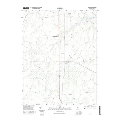
2016 Map of Ellendale
USGS Topo · Published 2016About this map
The town of Ellendale sits at the heart of this Sussex County landscape on the Delmarva Peninsula, where the geometric grid of agricultural fields meets the dense, tangled reaches of the Ellendale Swamp. This 2016 survey documents the rural character of the region, anchored by small settlements like Lincoln, Greentop, and Robbins. The landscape is defined by a complex network of small waterways and millponds, including Swiggetts Pond, Cubbage Pond, and Clendaniel Pond, which feed into branches such as Cedar Cr and Herring Br. For genealogists and local historians, the map preserves the locations of several burial sites, including Ellendale Cem, New Market Cem, and Banning Cem, scattered across the countryside. The presence of Hudson Pond Acres and Federalsburg alongside older crossroads like Oakley illustrates the gradual evolution of residential patterns within this traditional farming and timbering district.
Find a feature on this map
104 named features on this map. Tap any name to fly to it.
Don’t see what you’re looking for? This feature index may not catch every label — zoom into the map to look around manually.
Map Details
Editions of this 2016 Ellendale Map
This is the sole edition of this map. No revisions or reprints were ever made.
Other maps of this area

1915 · Seaford
USGS Topo · 1:62,500

1917 · Millsboro
USGS Topo · 1:62,500

1918 · Cedar Creek
USGS Topo · 1:62,500

1918 · Harrington
USGS Topo · 1:62,500

1919 · Cedar Creek
USGS Topo · 1:62,500

1938 · Cedar Creek
USGS Topo · 1:62,500

1938 · Millsboro
USGS Topo · 1:62,500
1944 · Milton
USGS Topo · 1:24,000

1944 · Cedar Creek
USGS Topo · 1:62,500

1944 · Millsboro
USGS Topo · 1:62,500