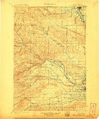
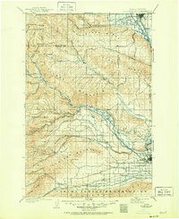
1901 Map of Ellensburg
USGS Topo · Published 1907About this map
Ellensburg and North Yakima anchor the north and south of this late-nineteenth-century landscape, connected by the vital Northern Pacific RR corridor along the Yakima River. The terrain is defined by a series of prominent southeast-trending ridges, including Manastash Ridge, Umptanum Ridge, and Cowiche Mountain, which dictate the drainage patterns of significant watercourses like the Naches River and Tieton River.
Find a feature on this map
48 named features on this map. Tap any name to fly to it.
Don’t see what you’re looking for? This feature index may not catch every label — zoom into the map to look around manually.
Map Details
Editions of this 1901 Ellensburg Map
6 editions found
Other maps of this area

1897 · Mount Stuart
USGS Topo · 1:125,000

1899 · Ellensburg
USGS Topo · 1:125,000

1901 · Ellensburg
USGS Topo · 1:125,000

1901 · Snoqualmie Pass
USGS Topo · 1:125,000

1902 · Mount Aix
USGS Topo · 1:125,000

1902 · Mount Stuart
USGS Topo · 1:125,000

1903 · Snoqualmie
USGS Topo · 1:125,000

1904 · Mt Aix
USGS Topo · 1:125,000

1904 · Mount Adams
USGS Topo · 1:125,000

1907 · Mount Adams
USGS Topo · 1:125,000