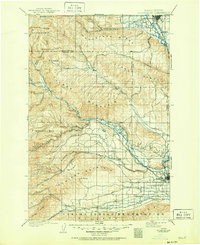
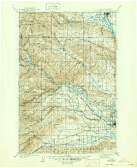
1901 Map of Ellensburg
USGS Topo · Published 1951About this map
The Yakima River valley serves as the central artery for this turn-of-the-century landscape, where the Northern Pacific R. R. follows the water south through Ellensburg and Thrall. The mapping reveals a stark transition from the irrigated agricultural basin around Yakima and Selah Creek to the high, ridged terrain of Manastash Ridge and Umtanum Ridge. The transportation network of 1899 is still clearly visible, including the winding Old Durr Road cutting through the highlands.
Find a feature on this map
50 named features on this map. Tap any name to fly to it.
Don’t see what you’re looking for? This feature index may not catch every label — zoom into the map to look around manually.
Map Details
Editions of this 1901 Ellensburg Map
6 editions found
Other maps of this area

1897 · Mount Stuart
USGS Topo · 1:125,000

1899 · Ellensburg
USGS Topo · 1:125,000

1901 · Ellensburg
USGS Topo · 1:125,000

1901 · Snoqualmie Pass
USGS Topo · 1:125,000

1902 · Mount Aix
USGS Topo · 1:125,000

1902 · Mount Stuart
USGS Topo · 1:125,000

1903 · Snoqualmie
USGS Topo · 1:125,000

1904 · Mt Aix
USGS Topo · 1:125,000

1904 · Mount Adams
USGS Topo · 1:125,000

1907 · Mount Adams
USGS Topo · 1:125,000