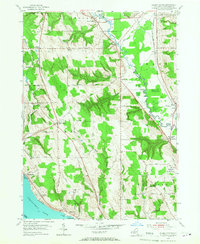
1954 Map of Ellery Center
USGS Topo · Published 1967About this map
Chautauqua Lake defines the southwestern corner of this mid-century landscape, where the shoreline hamlets of Belleview and Colburns meet the rising terrain of Ellery township. Further inland, the winding course of Cassadaga Creek anchors a low-lying valley used by the New York Central railroad, passing through the village of Gerry and the settlement of Redbird. The map captures a moment of local transition, showing the Jamestown Municipal Airport and the Jamestown Speedway established just north of the city limits.
Find a feature on this map
47 named features on this map. Tap any name to fly to it.
Don’t see what you’re looking for? This feature index may not catch every label — zoom into the map to look around manually.
Map Details
Editions of this 1954 Ellery Center Map
5 editions found
Other maps of this area

1900 · Dunkirk
USGS Topo · 1:62,500

1900 · Cherry Creek
USGS Topo · 1:62,500

1904 · Chautaqua
USGS Topo · 1:62,500

1905 · Jamestown
USGS Topo · 1:62,500

1941 · Cherry Creek
USGS Topo · 1:62,500

1941 · Chautauqua
USGS Topo · 1:62,500

1942 · Jamestown
USGS Topo · 1:62,500

1943 · Dunkirk
USGS Topo · 1:62,500

1954 · Chautauqua
USGS Topo · 1:24,000

1954 · Ellery Center
USGS Topo · 1:24,000