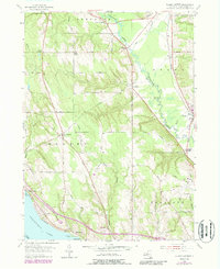
1954 Map of Ellery Center
USGS Topo · Published 1988About this map
Chautauqua Lake defines the southwestern corner of this mid-century survey, with the shoreline settlements of Colburns, Belleview, and Driftwood marking the water's edge. The landscape is a network of small upland communities and rural crossroads, including Ellery Center, South Stockton, and Kimball Stand. Local transportation and entertainment patterns of the 1950s are visible through the presence of the Jamestown Speedway and the County Airport in the southeastern quadrant.
Find a feature on this map
50 named features on this map. Tap any name to fly to it.
Don’t see what you’re looking for? This feature index may not catch every label — zoom into the map to look around manually.
Map Details
Editions of this 1954 Ellery Center Map
5 editions found
Other maps of this area

1900 · Dunkirk
USGS Topo · 1:62,500

1900 · Cherry Creek
USGS Topo · 1:62,500

1904 · Chautaqua
USGS Topo · 1:62,500

1905 · Jamestown
USGS Topo · 1:62,500

1941 · Cherry Creek
USGS Topo · 1:62,500

1941 · Chautauqua
USGS Topo · 1:62,500

1942 · Jamestown
USGS Topo · 1:62,500

1943 · Dunkirk
USGS Topo · 1:62,500

1954 · Chautauqua
USGS Topo · 1:24,000

1954 · Ellery Center
USGS Topo · 1:24,000