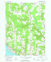
1954 Map of Ellery Center
USGS Topo · Published 1980About this map
Chautauqua Lake anchors the southwestern corner of this topographic study, where the shoreline hamlets of Colburns, Phillips Mills, and Belleview meet the rising plateau. Moving inland, the landscape is defined by the deep incision of Dutch Hollow and the broader valley of Cassadaga Creek, which winds through the eastern side of the quadrangle. This mid-century view captures the area as it transitioned from traditional agricultural crossroads to a more modern infrastructure, evidenced by the presence of the County Airport and the Jamestown Speedway. Historical intersections such as Ellery Center, South Stockton, and Kimball Stand reveal the enduring settlement patterns of central Chautauqua County. The map is particularly useful for tracing ancestral road networks, including family-named routes like Fenner Road and Pancake Hill Road, which connect these small rural communities across the varied terrain.
Find a feature on this map
49 named features on this map. Tap any name to fly to it.
Don’t see what you’re looking for? This feature index may not catch every label — zoom into the map to look around manually.
Map Details
Editions of this 1954 Ellery Center Map
5 editions found
Other maps of this area

1900 · Dunkirk
USGS Topo · 1:62,500

1900 · Cherry Creek
USGS Topo · 1:62,500

1904 · Chautaqua
USGS Topo · 1:62,500

1905 · Jamestown
USGS Topo · 1:62,500

1941 · Cherry Creek
USGS Topo · 1:62,500

1941 · Chautauqua
USGS Topo · 1:62,500

1942 · Jamestown
USGS Topo · 1:62,500

1943 · Dunkirk
USGS Topo · 1:62,500

1954 · Chautauqua
USGS Topo · 1:24,000

1954 · Ellery Center
USGS Topo · 1:24,000