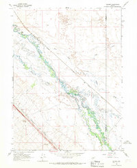
1966 Map of Ellison
USGS Topo · Published 1967About this map
The Humboldt River meanders through this Great Basin landscape, marking a vital water corridor in a region defined by its arid reaches and drainage patterns. This 1966 survey highlights a critical junction of infrastructure and agriculture, where the Western Pacific and Southern Pacific railroads traverse the valley near the Humboldt and Lander county line. Local ranching operations are anchored by the D-L Ranch and the 25 Ranch, while the confluence of the Reese River and the main Humboldt channel illustrates the complex hydrology of the valley floor. Evidence of early transit and settlement is visible at Ellison and Mote, alongside specialized water features like the Gaging Station and the branching McIntyre Slough. This map provides a detailed view of the high-desert valley before modern highway developments further altered the traditional rail-and-ranch landscape.
Find a feature on this map
17 named features on this map. Tap any name to fly to it.
Don’t see what you’re looking for? This feature index may not catch every label — zoom into the map to look around manually.
Map Details
Editions of this 1966 Ellison Map
Other maps of this area

1932 · Sonoma Range
USGS Topo · 1:250,000

1939 · Sonoma Range
USGS Topo · 1:250,000

1940 · Antler Peak
USGS Topo · 1:62,500

1943 · Antler Peak
USGS Topo · 1:62,500

1955 · Winnemucca
USGS Topo · 1:250,000

1957 · Battle Mountain
USGS Topo · 1:62,500

1958 · Winnemucca
USGS Topo · 1:250,000

1962 · Winnemucca
USGS Topo · 1:250,000

1965 · Knight
USGS Topo · 1:24,000

1965 · Russells
USGS Topo · 1:24,000