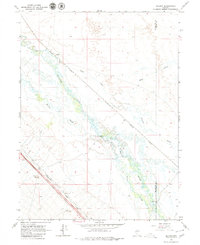
1966 Map of Ellison
USGS Topo · Published 1979About this map
The Humboldt River and Humboldt Reese River dominate this high-desert basin near the border of Humboldt and Lander Counties. In the mid-1960s, the landscape was defined by the intersection of natural waterways and major transportation corridors, with both the Western Pacific and Southern Pacific railroads cutting through the valley. Small ranching operations such as the D-L Ranch and 25 Ranch are established near the riverbanks, while the small settlement of Ellison sits along the rail line. The presence of several sloughs, including Herrin Slough and McIntyre Slough, indicates the seasonally shifting waters of this drainage system. Localized industry is evident in the Gravel Pits and a Gravel Pit located in the southwestern reaches, while hydrologic monitoring is marked by a Gaging Station on the river, reflecting the importance of water management in this arid cattle-ranching region.
Find a feature on this map
17 named features on this map. Tap any name to fly to it.
Don’t see what you’re looking for? This feature index may not catch every label — zoom into the map to look around manually.
Map Details
Editions of this 1966 Ellison Map
Other maps of this area

1932 · Sonoma Range
USGS Topo · 1:250,000

1939 · Sonoma Range
USGS Topo · 1:250,000

1940 · Antler Peak
USGS Topo · 1:62,500

1943 · Antler Peak
USGS Topo · 1:62,500

1955 · Winnemucca
USGS Topo · 1:250,000

1957 · Battle Mountain
USGS Topo · 1:62,500

1958 · Winnemucca
USGS Topo · 1:250,000

1962 · Winnemucca
USGS Topo · 1:250,000

1965 · Knight
USGS Topo · 1:24,000

1965 · Russells
USGS Topo · 1:24,000