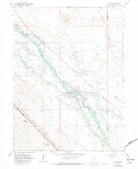
1966 Map of Ellison
USGS Topo · Published 1981About this map
The Humboldt River carves a complex, meandering path through this high desert basin, where the confluence with the Reese River marks a vital hydrologic junction near the Humboldt Co Lander Co line. During this mid-century period, the landscape is defined by the heavy infrastructure of the Western Pacific and Southern Pacific railroads, which run parallel to the river valley. These rail lines supported isolated outposts like Ellison and Mote, serving the regional ranching economy.
Find a feature on this map
23 named features on this map. Tap any name to fly to it.
Don’t see what you’re looking for? This feature index may not catch every label — zoom into the map to look around manually.
Map Details
Editions of this 1966 Ellison Map
Other maps of this area

1932 · Sonoma Range
USGS Topo · 1:250,000

1939 · Sonoma Range
USGS Topo · 1:250,000

1940 · Antler Peak
USGS Topo · 1:62,500

1943 · Antler Peak
USGS Topo · 1:62,500

1955 · Winnemucca
USGS Topo · 1:250,000

1957 · Battle Mountain
USGS Topo · 1:62,500

1958 · Winnemucca
USGS Topo · 1:250,000

1962 · Winnemucca
USGS Topo · 1:250,000

1965 · Knight
USGS Topo · 1:24,000

1965 · Russells
USGS Topo · 1:24,000