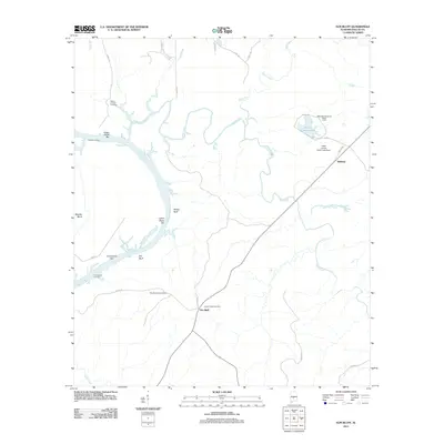
2011 Map of Elm Bluff
USGS Topo · Published 2011About this map
The Alabama River carves a sweeping path through this Dallas County landscape, defining the local geography with its numerous riverine features such as Molette Bend and Upper Sister Bar. The waterway served as a primary artery for the region, evidenced by historic river-access points like Saffold Landing and Providence Landing. These landings, along with high-ground settlements like Elm Bluff and Milton Bluff, reflect a settlement pattern deeply tied to the river's navigation and the fertile bottomlands.
Find a feature on this map
33 named features on this map. Tap any name to fly to it.
Don’t see what you’re looking for? This feature index may not catch every label — zoom into the map to look around manually.
Map Details
Editions of this 2011 Elm Bluff Map
This is the sole edition of this map. No revisions or reprints were ever made.
Other maps of this area

1953 · Montgomery
USGS Topo · 1:250,000

1956 · Montgomery
USGS Topo · 1:250,000

1957 · Montgomery
USGS Topo · 1:250,000

1957 · Carlowville
USGS Topo · 1:62,500

1957 · Benton
USGS Topo · 1:62,500

1957 · Braggs
USGS Topo · 1:62,500

1958 · Selma
USGS Topo · 1:62,500

1975 · Selma SE
USGS Topo · 1:24,000

1975 · Carlowville NE
USGS Topo · 1:24,000
1975 · Benton SW
USGS Topo · 1:24,000