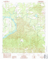
1987 Map of Elm Bluff
USGS Topo · Published 1987About this map
The Alabama River carves a massive, winding path through this Dallas County landscape, defining the topography with its dramatic oxbows and swampy lowlands. This 1980s-era documentation, based on 1981 aerial photography, highlights the rural character of the region where the small settlement of Belknap sits near the northern boundary. The terrain is characterized by the intricate drainage systems of Mush Creek and Cedar Creek, which feed into the main river channel. The river's path through the Molette Bend area illustrates the historical reliance on water transport and the natural barriers created by the shifting riverbed. This map captures the area just before the turn of the century, providing a clear record of land use and water features in a part of the state where the river has long been the primary geographic force.
Find a feature on this map
3 named features on this map. Tap any name to fly to it.
Don’t see what you’re looking for? This feature index may not catch every label — zoom into the map to look around manually.
Map Details
Editions of this 1987 Elm Bluff Map
This is the sole edition of this map. No revisions or reprints were ever made.
Other maps of this area

1953 · Montgomery
USGS Topo · 1:250,000

1956 · Montgomery
USGS Topo · 1:250,000

1957 · Montgomery
USGS Topo · 1:250,000

1957 · Carlowville
USGS Topo · 1:62,500

1957 · Benton
USGS Topo · 1:62,500

1957 · Braggs
USGS Topo · 1:62,500

1958 · Selma
USGS Topo · 1:62,500

1975 · Selma SE
USGS Topo · 1:24,000

1975 · Carlowville NE
USGS Topo · 1:24,000
1975 · Benton SW
USGS Topo · 1:24,000