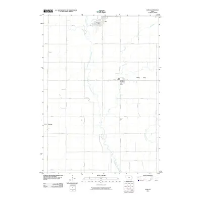
2010 Map of Elma
USGS Topo · Published 2010About this map
Elma and its surrounding agricultural landscape in Howard County are defined by a strict grid of section-line roads and the winding path of the Little Wapsipinicon River. The town of Elma serves as a central hub, anchored by the Elma Post Office and bordered by Mead Creek to the north. Further south, the map reveals smaller settlements and crossroads communities like Alta Vista, which hosts its own Alta Vista Post Office, and the locality of Deerfield. The geography transitions from the riparian corridors of Elk Creek and the East Fork Wapsipinicon River to the open expanse of Joachim Prairie. For those documenting local families, the survey provides precise locations for Calvary Cemetery, Union Cemetery, and Deerfield Cemetery, marking the resting places of early generations in this corner of Northeast Iowa.
Find a feature on this map
42 named features on this map. Tap any name to fly to it.
Don’t see what you’re looking for? This feature index may not catch every label — zoom into the map to look around manually.
Map Details
Editions of this 2010 Elma Map
This is the sole edition of this map. No revisions or reprints were ever made.
Other maps of this area

1954 · Mason City
USGS Topo · 1:250,000

1957 · Mason City
USGS Topo · 1:250,000

1958 · Mason City
USGS Topo · 1:250,000

1971 · Bassett
USGS Topo · 1:24,000

1971 · Colwell
USGS Topo · 1:24,000

1972 · Riceville
USGS Topo · 1:24,000
1972 · Ionia
USGS Topo · 1:24,000

1972 · Elma
USGS Topo · 1:24,000

1972 · Jerico
USGS Topo · 1:24,000
1972 · New Hampton
USGS Topo · 1:24,000