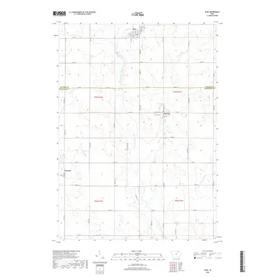
2018 Map of Elma
USGS Topo · Published 2018About this map
Elma and Alta Vista anchor this agricultural landscape along the northern border of Chickasaw County, where the headwaters of the Wapsipinicon River system emerge. The terrain is defined by the branching paths of the Little Wapsipinicon River and the E Fork Wapsipinicon River, which carve subtle drainage patterns through the sectioned farmland. For local historians and genealogists, the map identifies several key burial sites, including Calvary Cem and Union Cem situated near Alta Vista, and Deerfield Cem further south in the township of Deerfield. A dense grid of secondary roads like Co Line Rd and Co Hwy T76 connects the scattered homesteads and small municipal centers, reflecting the long-established rural infrastructure of this part of Northeast Iowa.
Find a feature on this map
54 named features on this map. Tap any name to fly to it.
Don’t see what you’re looking for? This feature index may not catch every label — zoom into the map to look around manually.
Map Details
Editions of this 2018 Elma Map
This is the sole edition of this map. No revisions or reprints were ever made.
Other maps of this area

1954 · Mason City
USGS Topo · 1:250,000

1957 · Mason City
USGS Topo · 1:250,000

1958 · Mason City
USGS Topo · 1:250,000

1971 · Bassett
USGS Topo · 1:24,000

1971 · Colwell
USGS Topo · 1:24,000

1972 · Riceville
USGS Topo · 1:24,000
1972 · Ionia
USGS Topo · 1:24,000

1972 · Elma
USGS Topo · 1:24,000

1972 · Jerico
USGS Topo · 1:24,000
1972 · New Hampton
USGS Topo · 1:24,000