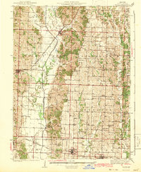
1942 Map of Elmer
USGS Topo · Published 1942About this map
The Chariton River carves a winding path through the center of this rural Macon County landscape, define by a dense network of country schools and churches. Surveyed in the late 1930s, the map reveals a highly localized social geography where small settlements like Elmer and Callao serve as hubs for the surrounding townships of Valley, Walnut Creek, and Liberty. The presence of numerous one-room schoolhouses, such as Jake Grove Sch and Milam Chapel Sch, reflects a pre-consolidation era of Missouri education.
Find a feature on this map
76 named features on this map. Tap any name to fly to it.
Don’t see what you’re looking for? This feature index may not catch every label — zoom into the map to look around manually.
Map Details
Editions of this 1942 Elmer Map
3 editions found
Other maps of this area

1903 · Edina
USGS Topo · 1:125,000

1908 · Atlanta
USGS Topo · 1:62,500

1908 · Macon
USGS Topo · 1:62,500

1910 · Macon
USGS Topo · 1:62,500

1937 · Elmer
USGS Topo · 1:48,000

1938 · Kirksville
USGS Topo · 1:62,500

1940 · Kirksville
USGS Topo · 1:62,500

1942 · Elmer
USGS Topo · 1:62,500

1950 · New Cambria West
USGS Topo · 1:24,000

1951 · New Boston
USGS Topo · 1:24,000