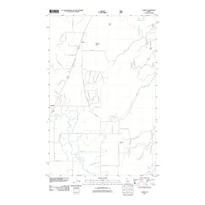
2011 Map of Elmira
USGS Topo · Published 2011About this map
Elmira and Samuels serve as the primary settlement hubs in this northern Idaho landscape, where the flat valley floor meets the rising timbered slopes of Elmira Peak. The drainage patterns of the Pack River and its many tributaries, including Sand Creek and Grouse Creek, define the local geography and historical transport routes. One of the more unique features recorded is the Bottle Bay Seaplane Base, indicating the region's reliance on both water and air for accessibility in the backcountry.
Find a feature on this map
52 named features on this map. Tap any name to fly to it.
Don’t see what you’re looking for? This feature index may not catch every label — zoom into the map to look around manually.
Map Details
Editions of this 2011 Elmira Map
This is the sole edition of this map. No revisions or reprints were ever made.
Other maps of this area

1901 · Sandpoint
USGS Topo · 1:125,000

1911 · Priest Lake
USGS Topo · 1:250,000

1911 · Sandpoint
USGS Topo · 1:125,000

1913 · Priest Lake
USGS Topo · 1:250,000

1951 · Elmira
USGS Topo · 1:62,500

1958 · Sandpoint
USGS Topo · 1:250,000

1963 · Sandpoint
USGS Topo · 1:250,000

1965 · Twentymile Creek
USGS Topo · 1:24,000

1965 · Naples
USGS Topo · 1:24,000
1967 · Dodge Peak
USGS Topo · 1:24,000