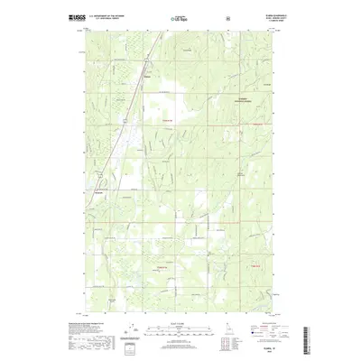
2020 Map of Elmira
USGS Topo · Published 2020About this map
The Kaniksu National Forest defines the rugged eastern landscape of this portion of Bonner County, where the Cabinet Mountains rise sharply above the river valleys. The settlement pattern is concentrated along the north-south transit corridor, anchored by the small communities of Elmira and Samuels. This area is characterized by a network of mountain drainage systems, most notably the Pack River and its various tributaries like Grouse Creek and Gold Creek. Local history and infrastructure are represented by the Gold Creek Cem and the Spear Valley Airport in the south. Higher elevations feature several isolated water bodies, including Bloom Lake, Dennick Lake, and Sand Lake near Sand Ridge. The map also details timber-related and access routes such as the Old Kootenai Trail and various Forest Service roads.
Find a feature on this map
91 named features on this map. Tap any name to fly to it.
Don’t see what you’re looking for? This feature index may not catch every label — zoom into the map to look around manually.
Map Details
Editions of this 2020 Elmira Map
This is the sole edition of this map. No revisions or reprints were ever made.
Other maps of this area

1901 · Sandpoint
USGS Topo · 1:125,000

1911 · Priest Lake
USGS Topo · 1:250,000

1911 · Sandpoint
USGS Topo · 1:125,000

1913 · Priest Lake
USGS Topo · 1:250,000

1951 · Elmira
USGS Topo · 1:62,500

1958 · Sandpoint
USGS Topo · 1:250,000

1963 · Sandpoint
USGS Topo · 1:250,000

1965 · Twentymile Creek
USGS Topo · 1:24,000

1965 · Naples
USGS Topo · 1:24,000
1967 · Dodge Peak
USGS Topo · 1:24,000