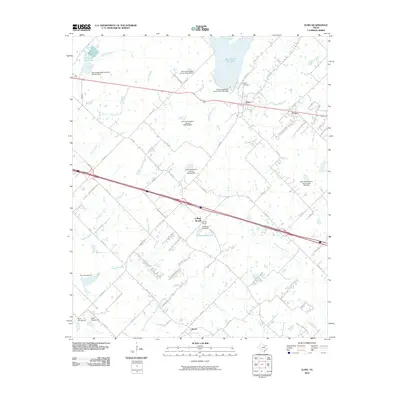
2010 Map of Elmo
USGS Topo · Published 2010About this map
Elmo and its surrounding rural hamlets are centered in this Kaufman County landscape, illustrating a transition between small agricultural settlements and managed water resources. North of the town, the New Terrell City Lake and Old Terrell City Lake dominate the upper watershed, while the southern landscape is dotted with smaller water management projects including the Tonkersley Lake Dam and numerous Soil Conservation Service sites. Small crossroads like Frog, College Mound, and Abner remain linked by a network of farm-to-market roads and county lanes such as Kaufman Rd and Abner Rd. The intricate drainage system of Hardin Branch, Eagans Creek, and Anthony Branch shapes the terrain, leading toward the Big Cottonwood Creek in the south. The presence of the Elmo Cemetery provides a fixed point for genealogical research in this long-settled part of North Texas.
Find a feature on this map
67 named features on this map. Tap any name to fly to it.
Don’t see what you’re looking for? This feature index may not catch every label — zoom into the map to look around manually.
Map Details
Editions of this 2010 Elmo Map
This is the sole edition of this map. No revisions or reprints were ever made.
Other maps of this area

1919 · Royse City
USGS Topo · 1:62,500

1954 · Dallas
USGS Topo · 1:250,000

1956 · Kaufman
USGS Topo · 1:62,500

1956 · Quinlan
USGS Topo · 1:62,500

1958 · Dallas
USGS Topo · 1:250,000

1962 · Elmo
USGS Topo · 1:24,000

1962 · Cedarvale
USGS Topo · 1:24,000

1962 · Wills Point
USGS Topo · 1:24,000
1962 · Ola
USGS Topo · 1:24,000
1962 · Terrell North
USGS Topo · 1:24,000