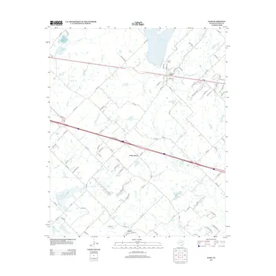
2012 Map of Elmo
USGS Topo · Published 2012About this map
Elmo stands as a primary settlement in this corner of Kaufman County, surrounded by a network of rural communities including Frog, College Mound, and Abner. The landscape is defined by the headwaters and branches of numerous local waterways, most notably Muddy Cedar Cr and Walnut Cr. Significant water infrastructure for the nearby population is visible through the New Terrell City Lake and Old Terrell City Lake in the northwest, reflecting the area's development.
Find a feature on this map
93 named features on this map. Tap any name to fly to it.
Don’t see what you’re looking for? This feature index may not catch every label — zoom into the map to look around manually.
Map Details
Editions of this 2012 Elmo Map
This is the sole edition of this map. No revisions or reprints were ever made.
Other maps of this area

1919 · Royse City
USGS Topo · 1:62,500

1954 · Dallas
USGS Topo · 1:250,000

1956 · Kaufman
USGS Topo · 1:62,500

1956 · Quinlan
USGS Topo · 1:62,500

1958 · Dallas
USGS Topo · 1:250,000

1962 · Elmo
USGS Topo · 1:24,000

1962 · Cedarvale
USGS Topo · 1:24,000

1962 · Wills Point
USGS Topo · 1:24,000
1962 · Ola
USGS Topo · 1:24,000
1962 · Terrell North
USGS Topo · 1:24,000