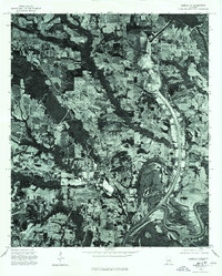
1975 Map of Elmore SE
USGS Topo · Published 1977About this map
The confluence of the Alabama River and the Coosa River dominates this mid-1970s orthophotoquad, showcasing the fluid transition from the Piedmont to the Coastal Plain. Unlike a traditional topographic map, this aerial survey provides a photographic record of the land use patterns near Elmore, revealing a patchwork of cleared agricultural fields and dense riparian corridors. The imagery captures the winding path of the rivers and the network of roads connecting rural homesteads and larger parcels of farmland during a period of steady development in Elmore County. This specialized view allows researchers to identify specific field boundaries and forest stands as they appeared before more recent suburban expansion around the state capital region.
Find a feature on this map
3 named features on this map. Tap any name to fly to it.
Don’t see what you’re looking for? This feature index may not catch every label — zoom into the map to look around manually.
Map Details
Editions of this 1975 Elmore SE Map
This is the sole edition of this map. No revisions or reprints were ever made.
Other maps of this area

1901 · Wetumpka
USGS Topo · 1:125,000

1901 · Wetumpka
USGS Topo · 1:62,500

1903 · Wetumpka
USGS Topo · 1:125,000

1927 · Montgomery
USGS Topo · 1:48,000

1930 · Montgomery
USGS Topo · 1:62,500

1953 · Montgomery
USGS Topo · 1:250,000

1956 · Montgomery
USGS Topo · 1:250,000

1957 · Montgomery
USGS Topo · 1:250,000

1958 · Montgomery
USGS Topo · 1:62,500

1958 · Montgomery North
USGS Topo · 1:24,000