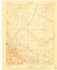
1897 Map of Elmoro
USGS Topo · Published 1909About this map
Trinidad serves as the focal point for this late 19th-century survey of Las Animas County, where the convergence of the Denver and Rio Grande R.R. and the Colorado and Southern R.R. drove a booming coal and transit economy. The landscape is defined by the canyon-carving paths of the Apishapa River and the Purgatory River, which provided crucial water in a high-desert environment.
Find a feature on this map
59 named features on this map. Tap any name to fly to it.
Don’t see what you’re looking for? This feature index may not catch every label — zoom into the map to look around manually.
Map Details
Editions of this 1897 Elmoro Map
5 editions found

Other maps of this area

1891 · Walsenburg
USGS Topo · 1:125,000

1891 · Spanish Peaks
USGS Topo · 1:125,000

1891 · Timpas
USGS Topo · 1:125,000

1891 · Apishapa
USGS Topo · 1:125,000

1891 · Mesa De Maya
USGS Topo · 1:125,000

1892 · Elmoro
USGS Topo · 1:125,000

1893 · Spanish Peaks
USGS Topo · 1:125,000

1893 · Apishapa
USGS Topo · 1:125,000

1893 · Elmoro
USGS Topo · 1:125,000

1893 · Mesa de Maya
USGS Topo · 1:125,000