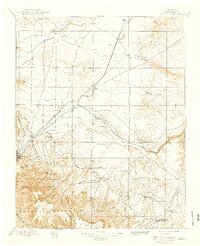
1897 Map of Elmoro
USGS Topo · Published 1939About this map
Trinidad serves as the focal point of this late 19th-century landscape, where the southern Colorado plains meet the dramatic rise of the Maxwell Grant. The map reveals a sophisticated late-1800s transportation corridor, as the Atchison Topeka and Santa Fe R. R. and the Denver and Rio Grande R. R. converge near Elmoro to follow the valley of the Purgatoire River. This river system, along with the Apishapa River to the north, dictated the placement of early settlements and agricultural outposts like Hoehne and Downing.
Find a feature on this map
50 named features on this map. Tap any name to fly to it.
Don’t see what you’re looking for? This feature index may not catch every label — zoom into the map to look around manually.
Map Details
Editions of this 1897 Elmoro Map
5 editions found

Other maps of this area

1891 · Walsenburg
USGS Topo · 1:125,000

1891 · Spanish Peaks
USGS Topo · 1:125,000

1891 · Timpas
USGS Topo · 1:125,000

1891 · Apishapa
USGS Topo · 1:125,000

1891 · Mesa De Maya
USGS Topo · 1:125,000

1892 · Elmoro
USGS Topo · 1:125,000

1893 · Spanish Peaks
USGS Topo · 1:125,000

1893 · Apishapa
USGS Topo · 1:125,000

1893 · Elmoro
USGS Topo · 1:125,000

1893 · Mesa de Maya
USGS Topo · 1:125,000