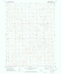
1973 Map of Elsie NW
USGS Topo · Published 1977About this map
Red Willow Creek winds through the heart of this Nebraska plains landscape, carving subtle drainage patterns across the terrain of Perkins County. The 1973 survey illustrates a rural environment defined by agricultural land divisions and the infrastructure of the central United States, most notably a large-scale Pipeline that cuts diagonally across the northern townships. This era of land use is further marked by the presence of scattered wells, indicating the localized development and water management necessary for life on the High Plains. The map's detailed recording of fence and field lines, interpreted from aerial photography, provides researchers with a precise record of historical property boundaries and grazing patterns during the early 1970s.
Find a feature on this map
5 named features on this map. Tap any name to fly to it.
Don’t see what you’re looking for? This feature index may not catch every label — zoom into the map to look around manually.
Map Details
Editions of this 1973 Elsie NW Map
This is the sole edition of this map. No revisions or reprints were ever made.
Other maps of this area

1897 · Ogallala
USGS Topo · 1:125,000

1898 · Paxton
USGS Topo · 1:125,000

1900 · Ogallala
USGS Topo · 1:125,000

1901 · Paxton
USGS Topo · 1:125,000

1954 · McCook
USGS Topo · 1:250,000

1954 · North Platte
USGS Topo · 1:250,000

1956 · North Platte
USGS Topo · 1:250,000

1957 · North Platte
USGS Topo · 1:250,000

1957 · McCook
USGS Topo · 1:250,000

1958 · McCook
USGS Topo · 1:250,000