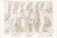
1956 Map of Ely
USGS Topo · Published 1973About this map
Ely and its neighboring rail hub East Ely serve as the central focus of this eastern Nevada basin and range landscape. The regional economy of the mid-twentieth century is clearly etched into the terrain, from the industrial activity at Ruth and the Pancake Coal Mine to the smelting and ranching interests near McGill. Transport corridors are vital here, with the Nevada Northern and Southern Pacific railroads threading through the high-desert valleys. The map illustrates a complex network of north-south mountain ranges, including the Cherry Creek Range and the Snake Range, which isolate expansive flats like Steptoe Valley and Spring Valley. This 1971 revision documents a transition era where traditional mining and ranching at places like Moorman Ranch persisted alongside federal land management in the Humboldt National Forest.
Find a feature on this map
41 named features on this map. Tap any name to fly to it.
Don’t see what you’re looking for? This feature index may not catch every label — zoom into the map to look around manually.
Map Details
Editions of this 1956 Ely Map
5 editions found

Other maps of this area

1908 · Fish Springs
USGS Topo · 1:250,000

1910 · Fish Springs
USGS Topo · 1:250,000

1925 · Gold Hill
USGS Topo · 1:62,500

1926 · Roberts Mountains
USGS Topo · 1:250,000

1928 · Gold Hill
USGS Topo · 1:62,500

1929 · Roberts Mountains
USGS Topo · 1:250,000

1934 · Jiggs
USGS Topo · 1:125,000

1937 · Mineral Hill
USGS Topo · 1:48,000

1937 · Jiggs
USGS Topo · 1:125,000

1943 · Mineral Hill
USGS Topo · 1:62,500