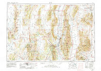
1956 Map of Ely
USGS Topo · Published 1980About this map
The high basin and range landscape of eastern Nevada centers on the mining and ranching hub of Ely, where the Nevada Northern railway connects remote outposts across the Steptoe Valley. This 1971 revision captures the region's industrial legacy, most notably at the mill and smelter complex near McGill and the clustered mining camps of Ruth, Kimberly, and Riepetown. To the west, the remnant mining activity in the White Pine Range is marked by the sites of Hamilton, Shermantown, and Eberhardt, reflecting the boom-and-bust cycles of 19th-century silver rushes.
Find a feature on this map
110 named features on this map. Tap any name to fly to it.
Don’t see what you’re looking for? This feature index may not catch every label — zoom into the map to look around manually.
Map Details
Editions of this 1956 Ely Map
5 editions found

Other maps of this area

1908 · Fish Springs
USGS Topo · 1:250,000

1910 · Fish Springs
USGS Topo · 1:250,000

1925 · Gold Hill
USGS Topo · 1:62,500

1926 · Roberts Mountains
USGS Topo · 1:250,000

1928 · Gold Hill
USGS Topo · 1:62,500

1929 · Roberts Mountains
USGS Topo · 1:250,000

1934 · Jiggs
USGS Topo · 1:125,000

1937 · Mineral Hill
USGS Topo · 1:48,000

1937 · Jiggs
USGS Topo · 1:125,000

1943 · Mineral Hill
USGS Topo · 1:62,500