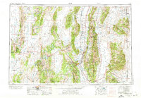
1956 Map of Ely
USGS Topo · Published 1973About this map
The high basins and north-south ranges of eastern Nevada define this mid-century survey, centered on the mining and rail hub of Ely. Significant industrial activity is concentrated at the Copper Flat Pit, Kimberly Pit, and Liberty Pit, served by the Nevada Northern RR. This area's transition from 19th-century boomtowns to modern extraction is evident in the numerous sites marked as ruins, including Hamilton, Treasure City, and Shermantown, which highlight the volatile nature of the White Pine mining district. Outside the industrial corridors of Steptoe Valley and Robinson Canyon, the landscape is managed by the Humboldt National Forest and includes the Goshute Indian Reservation on the Utah border. Cattle ranching and water management are visible through the network of valleys such as Newark Valley and Spring Valley, connected by the early alignments of U.S. 50 and U.S. 93.
Find a feature on this map
84 named features on this map. Tap any name to fly to it.
Don’t see what you’re looking for? This feature index may not catch every label — zoom into the map to look around manually.
Map Details
Editions of this 1956 Ely Map
5 editions found

Other maps of this area

1908 · Fish Springs
USGS Topo · 1:250,000

1910 · Fish Springs
USGS Topo · 1:250,000

1925 · Gold Hill
USGS Topo · 1:62,500

1926 · Roberts Mountains
USGS Topo · 1:250,000

1928 · Gold Hill
USGS Topo · 1:62,500

1929 · Roberts Mountains
USGS Topo · 1:250,000

1934 · Jiggs
USGS Topo · 1:125,000

1937 · Mineral Hill
USGS Topo · 1:48,000

1937 · Jiggs
USGS Topo · 1:125,000

1943 · Mineral Hill
USGS Topo · 1:62,500