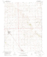
1980 Map of Emden
USGS Topo · Published 1980About this map
Emden and Hartsburg anchor this Central Illinois landscape, where the agricultural grid meets the diagonal path of the Illinois Central Gulf railroad. The map captures the interface of Tazewell and Logan Counties, centered on the townships of Boynton and Orvil. Settled across the level Prairie, the region is defined by its drainage into Prairie Creek, which snakes westward through the territory. Local history is marked by small rural gathering points like Bethel Church and the Patterson Cemetery near the northern boundary. The presence of these family-named landmarks and small-town plats illustrates the late-20th-century character of these farming communities, maintaining their spatial layout as it existed before significant modern consolidation altered the surrounding countryside.
Find a feature on this map
15 named features on this map. Tap any name to fly to it.
Don’t see what you’re looking for? This feature index may not catch every label — zoom into the map to look around manually.
Map Details
Editions of this 1980 Emden Map
This is the sole edition of this map. No revisions or reprints were ever made.
Other maps of this area

1911 · Lincoln
USGS Topo · 1:62,500

1913 · Lincoln
USGS Topo · 1:62,500

1942 · Delavan
USGS Topo · 1:62,500

1948 · Mason City
USGS Topo · 1:62,500

1949 · Mason City
USGS Topo · 1:62,500

1951 · Minier
USGS Topo · 1:62,500

1958 · Peoria
USGS Topo · 1:250,000

1961 · Peoria
USGS Topo · 1:250,000

1963 · Peoria
USGS Topo · 1:250,000
1971 · Delavan North
USGS Topo · 1:24,000