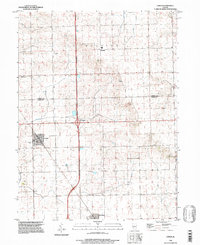
1996 Map of Emden
USGS Topo · Published 1997About this map
Emden and Hartsburg serve as the primary hubs in this section of the Illinois prairie during the mid-1990s. The landscape is defined by the rigid grid of agricultural townships, including Boynton and Orvil, and the diagonal path of the Illinois Central Railroad as it cuts through the heart of Emden. This rail corridor historically dictated the placement of grain elevators and town centers, a pattern that remains visible even as modern infrastructure like the Interchange 10 highway junction began to reshape local transit.
Find a feature on this map
16 named features on this map. Tap any name to fly to it.
Don’t see what you’re looking for? This feature index may not catch every label — zoom into the map to look around manually.
Map Details
Editions of this 1996 Emden Map
This is the sole edition of this map. No revisions or reprints were ever made.
Other maps of this area

1911 · Lincoln
USGS Topo · 1:62,500

1913 · Lincoln
USGS Topo · 1:62,500

1942 · Delavan
USGS Topo · 1:62,500

1948 · Mason City
USGS Topo · 1:62,500

1949 · Mason City
USGS Topo · 1:62,500

1951 · Minier
USGS Topo · 1:62,500

1958 · Peoria
USGS Topo · 1:250,000

1961 · Peoria
USGS Topo · 1:250,000

1963 · Peoria
USGS Topo · 1:250,000
1971 · Delavan North
USGS Topo · 1:24,000