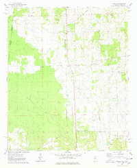
1974 Map of Emelle
USGS Topo · Published 1978About this map
The borderlands of Sumter County, Alabama, and Kemper County, Mississippi, appear in this mid-1970s survey, dominated by the ST Louis - San Francisco railroad corridor. The settlement of Emelle serves as a local hub, flanked by smaller communities like Hammer and Sledge. The landscape is a network of small creeks including Sicolocco Creek, Sanusi Creek, and Quailby Creek, which drain a countryside dotted with family-named landmarks and rural congregations. Several country churches and their associated grounds, such as Bethel Ch and the neighboring Bethel Cem, suggest long-standing community centers. To the south, industrial activity is marked by a Claypit, while the northern portion of the quadrangle shows the transition from timber and pasture into the Mississippi state line. Genealogists will find a high density of burial sites to trace, from Boney Cem in the northwest to Danner Cem and the Old Side Cem further east.
Find a feature on this map
27 named features on this map. Tap any name to fly to it.
Don’t see what you’re looking for? This feature index may not catch every label — zoom into the map to look around manually.
Map Details
Editions of this 1974 Emelle Map
2 editions found
Other maps of this area

1929 · Epes
USGS Topo · 1:48,000

1932 · Epes
USGS Topo · 1:62,500

1953 · Meridian
USGS Topo · 1:250,000

1957 · Meridian
USGS Topo · 1:250,000

1965 · Meridian
USGS Topo · 1:250,000

1970 · Gainesville
USGS Topo · 1:24,000

1973 · Scooba
USGS Topo · 1:24,000
1973 · Geiger
USGS Topo · 1:24,000

1974 · Boyd
USGS Topo · 1:24,000
1974 · Tamola
USGS Topo · 1:24,000