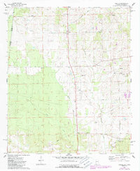
1974 Map of Emelle
USGS Topo · Published 1987About this map
Emelle serves as the focal point of this survey along the Mississippi Alabama state line, where the landscape is defined by the winding paths of Quilby Creek, Sicolocco Creek, and Little Sanusi Creek. The presence of an Old Railroad Grade running through the center of the sheet reflects a changing transportation network in the mid-1970s. The area is dotted with numerous rural spiritual and memorial sites, including Bethel Ch, St Peters Ch, and Shiloh Zion Ch, alongside family and community burial grounds such as Boney Cem, Bell Cem, and Foy Cem. Industrial activity is noted sparingly, notably at the Claypit in the southern portion of the quadrangle. The map also traces a major Pipeline cutting through the southern timberlands and fields.
Find a feature on this map
25 named features on this map. Tap any name to fly to it.
Don’t see what you’re looking for? This feature index may not catch every label — zoom into the map to look around manually.
Map Details
Editions of this 1974 Emelle Map
2 editions found
Other maps of this area

1929 · Epes
USGS Topo · 1:48,000

1932 · Epes
USGS Topo · 1:62,500

1953 · Meridian
USGS Topo · 1:250,000

1957 · Meridian
USGS Topo · 1:250,000

1965 · Meridian
USGS Topo · 1:250,000

1970 · Gainesville
USGS Topo · 1:24,000

1973 · Scooba
USGS Topo · 1:24,000
1973 · Geiger
USGS Topo · 1:24,000

1974 · Boyd
USGS Topo · 1:24,000
1974 · Tamola
USGS Topo · 1:24,000