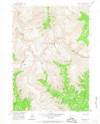
1956 Map of Emerald Lake
USGS Topo · Published 1967About this map
Shoshone National Forest defines this high-altitude landscape where the boundary between Park and Fremont counties traverses the peaks. Mapped during the mid-1950s, the terrain is characterized by a series of prominent summits including Lost Ranger Top, Red Tops, and the curiously named Devils Graveyard near Crescent Top. The drainage patterns are defined by numerous alpine water bodies such as Emerald Lake, Sheep Lake, and Green Lake, which feed into a complex network of mountain streams like Needle Creek and Venus Creek. Movement through this wilderness is traced by established routes like the Emerald Trail and a generic Pack Trail, which follow the natural contours of Sheep Creek and Emerald Creek. The map provides a detailed view of the Missouri River Basin development area prior to modern wilderness management, preserving the nomenclature of the era's surveyors and backcountry travelers.
Find a feature on this map
19 named features on this map. Tap any name to fly to it.
Don’t see what you’re looking for? This feature index may not catch every label — zoom into the map to look around manually.
Map Details
Editions of this 1956 Emerald Lake Map
4 editions found

Other maps of this area

1893 · Ishawooa
USGS Topo · 1:125,000

1895 · Ishawooa
USGS Topo · 1:125,000

1899 · Ishawooa
USGS Topo · 1:125,000

1904 · Kirwin
USGS Topo · 1:125,000

1905 · Younts Peak
USGS Topo · 1:125,000

1906 · Kirwin
USGS Topo · 1:125,000

1907 · Younts Peak
USGS Topo · 1:125,000

1955 · Cody
USGS Topo · 1:250,000

1955 · Thermopolis
USGS Topo · 1:250,000

1956 · Snow Lake
USGS Topo · 1:24,000