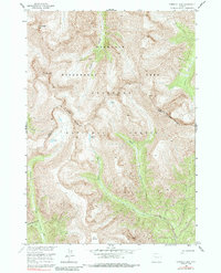
1956 Map of Emerald Lake
USGS Topo · Published 1985About this map
The high-altitude drainage systems of the Shoshone National Forest define this 1950s survey of the Absaroka Range. Within the Washakie Wilderness Area, the landscape is dominated by steep summits like Lost Ranger Top and the curiously named Devils Graveyard. A network of historic paths, including the Cougar Pass Pack Trail and Frontier Creek Pack Trail, provides the primary means of navigation through this roadless backcountry. The map captures the intersection of Park and Fremont counties as they divide these mountain headwaters. Small alpine water bodies, such as Emerald Lake and Sheep Lake, serve as the origins for Emerald Creek and Sheep Creek, respectively. The presence of named landmarks like Red Tops and Crescent Top suggests a terrain shaped by severe glaciation and erosion, documented here just as modern wilderness management practices were becoming formalized in the mid-20th century.
Find a feature on this map
22 named features on this map. Tap any name to fly to it.
Don’t see what you’re looking for? This feature index may not catch every label — zoom into the map to look around manually.
Map Details
Editions of this 1956 Emerald Lake Map
4 editions found

Other maps of this area

1893 · Ishawooa
USGS Topo · 1:125,000

1895 · Ishawooa
USGS Topo · 1:125,000

1899 · Ishawooa
USGS Topo · 1:125,000

1904 · Kirwin
USGS Topo · 1:125,000

1905 · Younts Peak
USGS Topo · 1:125,000

1906 · Kirwin
USGS Topo · 1:125,000

1907 · Younts Peak
USGS Topo · 1:125,000

1955 · Cody
USGS Topo · 1:250,000

1955 · Thermopolis
USGS Topo · 1:250,000

1956 · Snow Lake
USGS Topo · 1:24,000