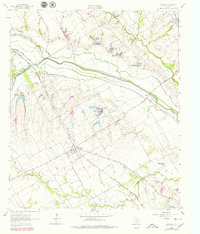
1962 Map of Emhouse
USGS Topo · Published 1979About this map
Chambers Creek and Waxahachie Creek converge in this northern Navarro County landscape, where the flat Texas plains are carved by an intricate network of drainage sloughs and flood control measures. The settlement of Emhouse serves as a central hub for the surrounding agricultural community, while the Chicago Rock Island and Pacific railroad cuts a diagonal line across the terrain, linking the small town of Rice to the regional rail economy.
Find a feature on this map
20 named features on this map. Tap any name to fly to it.
Don’t see what you’re looking for? This feature index may not catch every label — zoom into the map to look around manually.
Map Details
Editions of this 1962 Emhouse Map
2 editions found
Other maps of this area

1954 · Dallas
USGS Topo · 1:250,000

1956 · Ennis
USGS Topo · 1:62,500

1958 · Dallas
USGS Topo · 1:250,000

1961 · Chatfield
USGS Topo · 1:24,000

1962 · Emhouse
USGS Topo · 1:24,000

1962 · Ennis West
USGS Topo · 1:24,000

1962 · Ennis East
USGS Topo · 1:24,000

1962 · Rosser SW
USGS Topo · 1:24,000

1962 · Cryer Creek
USGS Topo · 1:24,000
1965 · Corsicana
USGS Topo · 1:24,000