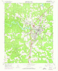
1963 Map of Emporia
USGS Topo · Published 1974About this map
Emporia sits at a major crossroads of Virginia rail and river geography, where the Meherrin River meets the heavy rail corridors of the Seaboard Coast Line Railroad and the Norfolk Franklin and Danville Railroad. The landscape reflects a mix of civic expansion and rural traditions, featuring institutions like the Greensville Memorial Hospital and the Greensville Community Center alongside numerous small country sanctuaries such as St Johns Ch and Union Grove Ch. Water dominates the eastern and southern edges of the settlement, with Metcalf Branch and Falling Run draining toward Mill Swamp. The presence of the Radio Tower (WEVA) and a Filtration Plant WT mark the infrastructure of the mid-20th-century city, while outlying areas like Bufford Crossroads and Moonlight maintain their character as distinct rural junctions near the timber-rich swamplands.
Find a feature on this map
43 named features on this map. Tap any name to fly to it.
Don’t see what you’re looking for? This feature index may not catch every label — zoom into the map to look around manually.
Map Details
Editions of this 1963 Emporia Map
5 editions found

Other maps of this area

1919 · Jarratt
USGS Topo · 1:62,500

1919 · Mc Kenney
USGS Topo · 1:48,000

1919 · Emporia
USGS Topo · 1:62,500

1919 · Arringdale
USGS Topo · 1:48,000

1920 · Arringdale
USGS Topo · 1:62,500

1921 · Mc Kenney
USGS Topo · 1:62,500

1942 · Arringdale
USGS Topo · 1:62,500

1942 · Emporia
USGS Topo · 1:62,500

1943 · Mc Kenney
USGS Topo · 1:62,500

1951 · Jarratt
USGS Topo · 1:62,500