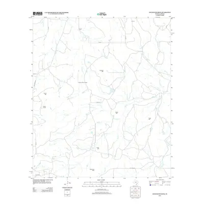
2012 Map of Enchanted Rock
USGS Topo · Published 2012About this map
Enchanted Rock stands as the primary landmark of this central Texas landscape, which is defined by a network of seasonal drainages and prominent granite domes. The area's history is preserved at the Rossberg Cem and Moss Cem, marking generations of settlement along the waterways of Sandy Creek and its many tributaries. The terrain transitions from the elevations of Bullhead Mtn and Watch Mtn down toward the winding course of Walnut Spring Cr. Transportation routes like Ranch Road 965 and FM-2323 connect the remote ranching properties, including the Mc David Ranch Airport. The map documents a landscape where traditional land use meets local geography, evidenced by features such as Honey Spring and Wright Knobs that have likely served as local points of reference for decades.
Find a feature on this map
34 named features on this map. Tap any name to fly to it.
Don’t see what you’re looking for? This feature index may not catch every label — zoom into the map to look around manually.
Map Details
Editions of this 2012 Enchanted Rock Map
This is the sole edition of this map. No revisions or reprints were ever made.
Other maps of this area
1887 · Llano
USGS Topo · 1:125,000
1894 · Fredericksburg
USGS Topo · 1:125,000
1894 · Llano
USGS Topo · 1:125,000
1904 · Llano
USGS Topo · 1:125,000
1909 · Llano
USGS Topo · 1:125,000
1918 · Llano
USGS Topo · 1:125,000
1954 · Llano
USGS Topo · 1:250,000
1955 · Llano
USGS Topo · 1:250,000
1956 · Llano
USGS Topo · 1:250,000
1960 · Scotts Crossing
USGS Topo · 1:24,000