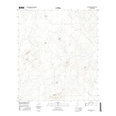
2016 Map of Enchanted Rock
USGS Topo · Published 2016About this map
Enchanted Rock dominates the southern portion of this Llano County landscape, anchoring a terrain defined by granite domes and winding waterways. The topography is shaped by significant heights like Watch Mtn, Dutch Mtn, and the Wright Knobs, with the drainage network including Sandy Cr and Honey Spring flowing between these peaks. Evidence of local ranching history is visible in the network of unpaved roads and the presence of the Mc David Ranch Airport. Family and community history is preserved through sites such as Rossberg Cem and Moss Cem, located near the northern reaches of Bullhead Cr and Bennett Cr. The prevalence of named springs and creek branches, including Prairie Mountain Spring Br and Walnut Spring, suggests a landscape where water sources were essential for the homesteads and cattle operations that established these roads.
Find a feature on this map
37 named features on this map. Tap any name to fly to it.
Don’t see what you’re looking for? This feature index may not catch every label — zoom into the map to look around manually.
Map Details
Editions of this 2016 Enchanted Rock Map
This is the sole edition of this map. No revisions or reprints were ever made.
Other maps of this area
1887 · Llano
USGS Topo · 1:125,000
1894 · Fredericksburg
USGS Topo · 1:125,000
1894 · Llano
USGS Topo · 1:125,000
1904 · Llano
USGS Topo · 1:125,000
1909 · Llano
USGS Topo · 1:125,000
1918 · Llano
USGS Topo · 1:125,000
1954 · Llano
USGS Topo · 1:250,000
1955 · Llano
USGS Topo · 1:250,000
1956 · Llano
USGS Topo · 1:250,000
1960 · Scotts Crossing
USGS Topo · 1:24,000