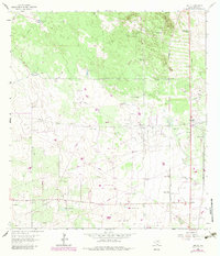
1963 Map of Encino
USGS Topo · Published 1983About this map
Tepeguaje Ranch and the community of Encino anchor this South Texas landscape during a period of expanding energy infrastructure. The map reveals a high concentration of water sources critical to ranching and industry, including La Venada Well, Agua Dulce Well, and Juan Well. The economy of Brooks County is characterized here by the Rachal Oil Field and the Southern Pacific rail line, which supported the transport of cattle and resources from remote locations like Rachal Siding. Local history is preserved in sites such as Villarreal Cem and named family landmarks like Plano de Choche. The terrain transitions from the dunes of Los Muertos in the northeast to the flat reaches of Alta Mesa in the southwest, while natural water features like Laguna Salada and La Redonda Lake provide distinct geographic markers amidst a network of industrial pipelines.
Find a feature on this map
51 named features on this map. Tap any name to fly to it.
Don’t see what you’re looking for? This feature index may not catch every label — zoom into the map to look around manually.
Map Details
Editions of this 1963 Encino Map
2 editions found
Other maps of this area

1921 · Falfurrias
USGS Topo · 1:125,000

1939 · Encantada
USGS Topo · 1:62,500

1949 · Mc Allen
USGS Topo · 1:250,000

1954 · McAllen
USGS Topo · 1:250,000

1956 · Laredo
USGS Topo · 1:250,000

1957 · Mc Allen
USGS Topo · 1:250,000

1962 · McAllen
USGS Topo · 1:250,000

1963 · Falfurrias SE
USGS Topo · 1:24,000

1963 · Cage Ranch
USGS Topo · 1:24,000
1963 · Callo Padrones
USGS Topo · 1:24,000