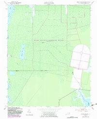
1953 Map of Engelhard NW
USGS Topo · Published 1983About this map
The Dare County Bombing Range (USAF) dominates this coastal landscape, showing a massive bullseye target and cleared areas within the marshy interior. This 1953 survey, updated with 1980s aerial data, reveals a transition between the Alligator River and the Long Shoal River. The terrain is defined by complex hydrology, where Whipping Creek feeds into Whipping Creek Lake amidst an expanse of wetlands. Along the southern boundary, the Dare Co Hyde Co line runs through remote territory marked by an Indefinite Boundary, illustrating the difficulty of surveying this swampy region. The presence of Swan Creek Lake and numerous benchmark markers like BM 2 and BM 5 along the few established routes, including Route 264, highlight the isolation and specialized military use of the area during the mid-to-late 20th century.
Find a feature on this map
15 named features on this map. Tap any name to fly to it.
Don’t see what you’re looking for? This feature index may not catch every label — zoom into the map to look around manually.
Map Details
Editions of this 1953 Engelhard NW Map
4 editions found
Other maps of this area

1943 · Columbia
USGS Topo · 1:125,000

1943 · Roanoke Island
USGS Topo · 1:125,000

1951 · Engelhard West
USGS Topo · 1:24,000

1951 · Long Shoal Point
USGS Topo · 1:24,000

1951 · Engelhard East
USGS Topo · 1:24,000

1953 · Engelhard NW
USGS Topo · 1:24,000

1953 · Buffalo City
USGS Topo · 1:24,000

1953 · Fairfield NE
USGS Topo · 1:24,000

1953 · East Lake SE
USGS Topo · 1:24,000

1953 · Engelhard NE
USGS Topo · 1:24,000