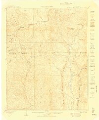
1908 Map of Engineer Mountain
USGS Topo · Published 1909About this map
Hermosa Park and the high peaks of the San Miguel Mountains dominate this early 20th-century survey of the Colorado high country. The landscape is defined by the steep transition from the Siderock Ridge and Engineer Mtn down toward the Rio Animas River valley. A critical transportation corridor is visible along the eastern edge of the map, where the Denver and Rio Grande R R follows the river, serving mountain outposts like Tacoma and Cascade Siding.
Find a feature on this map
58 named features on this map. Tap any name to fly to it.
Don’t see what you’re looking for? This feature index may not catch every label — zoom into the map to look around manually.
Map Details
Editions of this 1908 Engineer Mountain Map
3 editions found

Other maps of this area

1895 · La Plata
USGS Topo · 1:62,500

1897 · La Plata
USGS Topo · 1:62,500

1897 · Rico
USGS Topo · 1:62,500

1897 · Telluride
USGS Topo · 1:62,500

1897 · Silverton
USGS Topo · 1:62,500

1898 · Durango
USGS Topo · 1:62,500

1898 · Engineer Mountain
USGS Topo · 1:62,500

1898 · Rico
USGS Topo · 1:62,500

1899 · La Plata
USGS Topo · 1:62,500

1899 · Rico
USGS Topo · 1:62,500