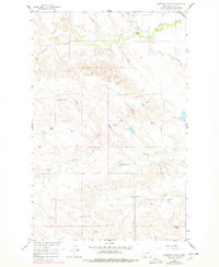
1958 Map of Engstrom Ranch
USGS Topo · Published 1978About this map
Billingsley Ranch and the winding course of Antelope Creek anchor the northern landscape of this Valley County terrain, documented during the late 1950s as part of the Missouri River Basin development program. The map reveals a sophisticated network of water management, evidenced by numerous numbered catchments like Reservoir No 145 and Reservoir No 168, alongside the South Canal and its associated Road on Levee. These features illustrate the intense focus on irrigation and ranching infrastructure in the High Plains. Southward, family-named landmarks such as Uphaus Ranch and Engstrom Ranch sit among the drainages of Brazil Creek and Little Brazil Creek. Local industry is represented by Gravel Pits near the creek bends, while the Mahan and Hoyt Res points to specific historical land and water use by local families.
Find a feature on this map
17 named features on this map. Tap any name to fly to it.
Don’t see what you’re looking for? This feature index may not catch every label — zoom into the map to look around manually.
Map Details
Editions of this 1958 Engstrom Ranch Map
2 editions found
Other maps of this area

1943 · Glasgow
USGS Topo · 1:125,000

1954 · Glasgow
USGS Topo · 1:250,000

1957 · Glasgow
USGS Topo · 1:250,000

1958 · Glasgow
USGS Topo · 1:250,000

1958 · Engstrom Ranch
USGS Topo · 1:24,000

1958 · Miller Coulee
USGS Topo · 1:62,500

1958 · Glasgow
USGS Topo · 1:24,000
1958 · Blanchard Ranch
USGS Topo · 1:24,000
1958 · Billick Coulee
USGS Topo · 1:24,000
1969 · Tampico
USGS Topo · 1:24,000