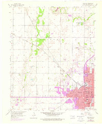
1955 Map of Enid West
USGS Topo · Published 1976About this map
The western half of Enid serves as the focal point of this mid-century survey, illustrating the city's suburban expansion and its deep-rooted rail infrastructure. Three major railroads, the Atchison Topeka and Santa Fe, the St Louis San Francisco and Santa Fe, and the Chicago Rock Island and Pacific, converge here, reflecting the importance of this hub to the Oklahoma wheat belt. A purple overprint indicates urban growth as of 1975, showing the westward push of residential streets like Oklahoma Ave and Thompson Ave. Local life is anchored by numerous neighborhood schools such as McKinley Sch and Harrison Sch, along with the County Fairground and a Drive-in Theater on the city's edge. Beyond the city limits, the terrain opens into the agricultural fields of Garland and Banner townships, marked by small settlements like Blanton and Jonah.
Find a feature on this map
50 named features on this map. Tap any name to fly to it.
Don’t see what you’re looking for? This feature index may not catch every label — zoom into the map to look around manually.
Map Details
Editions of this 1955 Enid West Map
3 editions found
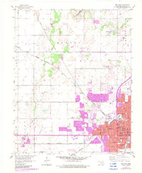
Other maps of this area

1955 · Enid West
USGS Topo · 1:24,000

1955 · Enid East
USGS Topo · 1:24,000

1955 · Enid
USGS Topo · 1:250,000

1955 · Woodward
USGS Topo · 1:250,000

1956 · Enid
USGS Topo · 1:62,500

1956 · Ringwood
USGS Topo · 1:62,500

1958 · Enid
USGS Topo · 1:250,000

1958 · Woodward
USGS Topo · 1:250,000

1968 · Hillsdale
USGS Topo · 1:24,000

1968 · Kremlin
USGS Topo · 1:24,000