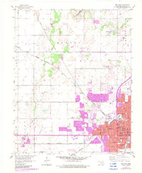
1955 Map of Enid West
USGS Topo · Published 1983About this map
The western expansion of Enid is documented here through a complex web of industrial and civic infrastructure. The city's growth is anchored by its position as a regional rail hub, where the Atchison Topeka and Santa Fe, Burlington Northern, and Chicago Rock Island and Pacific lines converge. Urban development, noted in purple revisions, pushes westward toward Blanton and Jonah, while established civic institutions like St Joseph Sch and Harrison Sch populate the central district.
Find a feature on this map
48 named features on this map. Tap any name to fly to it.
Don’t see what you’re looking for? This feature index may not catch every label — zoom into the map to look around manually.
Map Details
Editions of this 1955 Enid West Map
3 editions found
Other maps of this area

1955 · Enid West
USGS Topo · 1:24,000

1955 · Enid East
USGS Topo · 1:24,000

1955 · Enid
USGS Topo · 1:250,000

1955 · Woodward
USGS Topo · 1:250,000

1956 · Enid
USGS Topo · 1:62,500

1956 · Ringwood
USGS Topo · 1:62,500

1958 · Enid
USGS Topo · 1:250,000

1958 · Woodward
USGS Topo · 1:250,000

1968 · Hillsdale
USGS Topo · 1:24,000

1968 · Kremlin
USGS Topo · 1:24,000