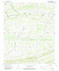
1963 Map of Enola
USGS Topo · Published 1986About this map
Enola serves as the central hub of this 1963 landscape, where the agricultural flats of northern Faulkner County meet the rising elevations of Cascade Mountain. The terrain is defined by a dense network of waterways including East Fork Cadron Creek and Muddy Bayou, which historically shaped the placement of local settlements and farmsteads. Small rural centers like Naylor and Mount Vernon are anchored by community institutions such as the Naylor Ch and Bethlehem Ch, reflecting the area's mid-century social fabric.
Find a feature on this map
38 named features on this map. Tap any name to fly to it.
Don’t see what you’re looking for? This feature index may not catch every label — zoom into the map to look around manually.
Map Details
Editions of this 1963 Enola Map
2 editions found
Other maps of this area

1956 · Russellville
USGS Topo · 1:250,000

1961 · Conway
USGS Topo · 1:62,500

1961 · Bee Branch
USGS Topo · 1:62,500

1961 · Guy
USGS Topo · 1:24,000
1961 · Holland
USGS Topo · 1:24,000
1961 · Hamlet
USGS Topo · 1:24,000

1963 · Rose Bud
USGS Topo · 1:24,000

1963 · Enola
USGS Topo · 1:24,000

1963 · Mount Vernon
USGS Topo · 1:24,000
1963 · Mountain Springs
USGS Topo · 1:24,000