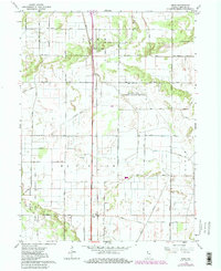
1962 Map of Enos
USGS Topo · Published 1980About this map
Beaver Lake Prairie Chicken Refuge anchors the center of this Newton County landscape, a region defined by an extensive network of drainage infrastructure designed to reclaim agricultural land from the historic marshes. The map reveals the strictly gridded development of McClellan and Colfax townships, where numbered thoroughfares like 400 North Road and 800 North Road segment the terrain. This drainage system is meticulously documented, from Best Ditch in the northwest to the winding Beaver Creek and Bergren Ditch in the south.
Find a feature on this map
29 named features on this map. Tap any name to fly to it.
Don’t see what you’re looking for? This feature index may not catch every label — zoom into the map to look around manually.
Map Details
Editions of this 1962 Enos Map
Other maps of this area

1922 · Momence
USGS Topo · 1:62,500

1924 · Momence
USGS Topo · 1:62,500

1935 · Watseka
USGS Topo · 1:48,000

1939 · Watseka
USGS Topo · 1:62,500

1953 · Chicago
USGS Topo · 1:250,000

1953 · Danville
USGS Topo · 1:250,000

1955 · Danville
USGS Topo · 1:250,000

1956 · Danville
USGS Topo · 1:250,000

1957 · Chicago
USGS Topo · 1:250,000

1959 · Schneider
USGS Topo · 1:24,000