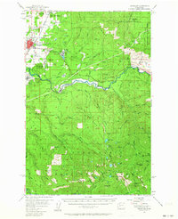
1956 Map of Enumclaw
USGS Topo · Published 1964About this map
Industrial timber and mining operations define the mid-century landscape around Enumclaw, where the Northern Pacific railroad and the Pacific Northern Logging Road intersect a network of gravel pits and quarries. The sheet documents significant infrastructure along the White River, notably the Mud Mtn Dam Spillway and the controlled inundation of Mud Mountain Lake. To the south and east, the terrain rises into the Snoqualmie National Forest, marked by remote shelters like Double Camp Shelter and high-elevation prospects including the Copper King Mine and Queen Bee Mine. Smaller rural communities like Krain, Veazey, and Boise appear alongside institutional landmarks such as the Rainier State Sch. The map records a complex transition from valley agriculture and logging to protected forest lands and federal water management projects.
Find a feature on this map
87 named features on this map. Tap any name to fly to it.
Don’t see what you’re looking for? This feature index may not catch every label — zoom into the map to look around manually.
Map Details
Editions of this 1956 Enumclaw Map

Other maps of this area

1897 · Tacoma
USGS Topo · 1:125,000

1900 · Tacoma
USGS Topo · 1:125,000

1913 · Cedar Lake
USGS Topo · 1:125,000

1924 · Mt Rainier
USGS Topo · 1:96,000

1928 · Mt Rainier
USGS Topo · 1:125,000

1937 · Eatonville
USGS Topo · 1:125,000

1942 · Lake Tapps
USGS Topo · 1:62,500

1944 · Lake Tapps
USGS Topo · 1:62,500

1949 · Black Diamond
USGS Topo · 1:24,000

1950 · Yakima
USGS Topo · 1:250,000