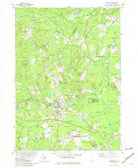
1981 Map of Epping
USGS Topo · Published 1981About this map
Epping and the surrounding Rockingham County landscape are defined by the convergence of the Lamprey River and the Piscassic River, where the historic Boston and Maine Railroad corridor intersects the local road network. The map reveals a cluster of early settlements including Nottingham Square, Wadley Falls, and the religious grounds of Camp Hedding. Genealogists will find a high density of family burial grounds such as Sleeper Cem, Ladd Cem, and Wiggin Cem, scattered across the undulating terrain of Redoak Hill and Isinglass Hill. The presence of the Rockingham and Strafford County line and the Smith State Forest highlights the region's mix of municipal structure and conserved woodlands, while labels for Watson Academy and the local Town Hall mark the civic centers of these long-established New England towns.
Find a feature on this map
72 named features on this map. Tap any name to fly to it.
Don’t see what you’re looking for? This feature index may not catch every label — zoom into the map to look around manually.
Map Details
Editions of this 1981 Epping Map
This is the sole edition of this map. No revisions or reprints were ever made.
Other maps of this area

1888 · Newburyport
USGS Topo · 1:62,500

1888 · Haverhill
USGS Topo · 1:62,500

1890 · Haverhill
USGS Topo · 1:62,500

1890 · Newburyport
USGS Topo · 1:62,500

1893 · Dover
USGS Topo · 1:62,500

1893 · Haverhill
USGS Topo · 1:62,500

1894 · Newburyport
USGS Topo · 1:62,500

1916 · Dover
USGS Topo · 1:62,500

1917 · Mt. Pawtuckaway
USGS Topo · 1:62,500

1918 · Dover
USGS Topo · 1:62,500