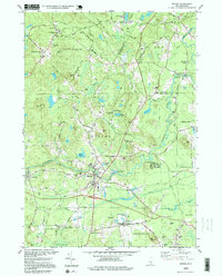
1995 Map of Epping
USGS Topo · Published 1999About this map
Epping and the surrounding Rockingham County townships are defined by the winding course of the Lamprey River, which anchors several historic village centers. At Wadley Falls, the river's descent provided the site for early industry, while the community of Nottingham Square remains a prominent upland landmark. The map documents the residential and agricultural footprint of the mid-1990s, showcasing established institutions like Watson Academy and the religious assembly grounds at Camp Hedding.
Find a feature on this map
84 named features on this map. Tap any name to fly to it.
Don’t see what you’re looking for? This feature index may not catch every label — zoom into the map to look around manually.
Map Details
Editions of this 1995 Epping Map
This is the sole edition of this map. No revisions or reprints were ever made.
Other maps of this area

1888 · Newburyport
USGS Topo · 1:62,500

1888 · Haverhill
USGS Topo · 1:62,500

1890 · Haverhill
USGS Topo · 1:62,500

1890 · Newburyport
USGS Topo · 1:62,500

1893 · Dover
USGS Topo · 1:62,500

1893 · Haverhill
USGS Topo · 1:62,500

1894 · Newburyport
USGS Topo · 1:62,500

1916 · Dover
USGS Topo · 1:62,500

1917 · Mt. Pawtuckaway
USGS Topo · 1:62,500

1918 · Dover
USGS Topo · 1:62,500