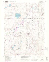
1967 Map of Erie
USGS Topo · Published 1980About this map
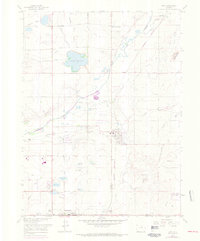
Coal Creek and the Union Pacific railroad corridor anchor the settlement patterns of this plains landscape during a period of transition. The town of Erie sits at the center, serving as a hub for nearby industrial sites like the Columbine Mine and the Hayward Mine, which reflect the region's historical reliance on coal extraction. To the south, the expansion of Lafayette is evident, while smaller rail-stops and communities such as Canfield, Tabor, and Leyner dot the countryside. An extensive network of irrigation infrastructure, including the Boulder and Whitelock Ditch and the Northern Burlington Ditch, supports agricultural tracts alongside water bodies like Panama Res No 1 and Elmwood Reservoir. The map also captures local aviation history at the Tri-County Airport and the development of major local thoroughfares like Niwot Road and Mineral Road.
Find a feature on this map
48 named features on this map. Tap any name to fly to it.
Don’t see what you’re looking for? This feature index may not catch every label — zoom into the map to look around manually.
Map Details
Editions of this 1967 Erie Map
6 editions found
Other maps of this area

1890 · East Denver
USGS Topo · 1:125,000

1899 · West Denver
USGS Topo · 1:125,000

1902 · Greeley
USGS Topo · 1:125,000

1904 · Niwot
USGS Topo · 1:62,500

1940 · Eastlake
USGS Topo · 1:31,680

1940 · Lafayette
USGS Topo · 1:31,680

1942 · Louisville
USGS Topo · 1:31,680

1944 · Lafayette
USGS Topo · 1:31,680

1944 · Eastlake
USGS Topo · 1:31,680

1949 · Gowanda
USGS Topo · 1:24,000